

Road Atlas for the Annular Solar Eclipse of 2023 - Color Edition [By Espenak]
Availability: Item has been discontinued by the manufacturer
Contiguous US Customers:
All items we sell ship for free within the Contiguous US. Shipping will be via the cheapest shipping method which will vary depending on the items in your order. During checkout, you may also be shown other optional faster shipping choices.
US Customers in Hawaii and Alaska:
Free shipping applies to almost all products. A few large telescopes and mounts are excluded from this free shipping offer. For these items, please contact us to obtain a shipping quote before you check out using the online shopping cart.
International Customers:
Free shipping does not apply to international orders. During check-out, you will be presented with several shipping choices and costs. However, the export of some items may be restricted outside the US due to size or manufacturer restrictions.
Title: Road Atlas for the Annual Solar Eclipse of 2023 - Color Edition
Author(s): Fred Espenak
Other Info: 8.5" by 11"
On Saturday, October 14, 2023, an annular eclipse of the Sun will be visible from parts of the United States. Although a partial eclipse will be seen from all of North America, the annular phase in which the Moon’s disk is completely silhouetted by the Sun (known as annularity) is only visible from a narrow path of the Moon’s antumbral shadow as it sweeps through the western USA (Oregon, California, Idaho, Nevada, Utah, Colorado, Arizona, New Mexico, and Texas), Mexico, Central and South America.
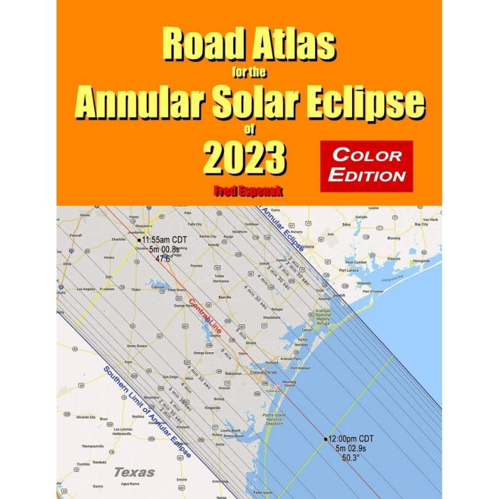
Road Atlas for the Annular Solar Eclipse of 2023 contains a comprehensive series of 29 maps of the path of annularity across the USA, Mexico, Central and South America. The large scale (1 inch ≈ 28 miles) shows both major and minor roads, towns and cities, rivers, lakes, parks, national forests, wilderness areas and mountain ranges. The map below is an example from the Road Atlas covering the Texas Gulf Coast.
The path of annularity on each map is depicted as a lightly shaded region with the northern and southern limits clearly identified. The annular eclipse can be seen only inside this path. The closer one gets to the central line of the path, the longer the annular eclipse lasts. Gray lines inside the path mark the duration of the annular eclipse in 30 second steps. This makes it easy to estimate the duration of annularity from any location in the eclipse path.
Yellow lines running across the path at 5-minute intervals indicate the local time of mid-eclipse. Where they cross the central line (plotted in red) the local time, central line duration of annularity and the Sun's altitude are labeled. This eliminates the need to look these details up on a table.
The 2023 Road Atlas also features six tables giving eclipse times and circumstances for hundreds of cities throughout North and South America.
Armed with this atlas and the latest weather forecasts, the road warrior is ready to chase annularity no matter where it takes him/her along the entire path. This mobile strategy offers the highest probability of witnessing the amazing 2023 annular eclipse in clear skies.
| Product Banner Type | discontinued |
|---|---|
| Free Shipping Graphic | Free US Shipping |
| Hide Found a better Shipped Price on Frontend? | No |

![Eclipse Bulletin: Total Solar Eclipse of 2024 April 8 - Color Edition [By Espenak and Anderson]](https://staging-njihxu5zv387.agenaastro.com/media/catalog/product/cache/67ee89799642c567a71fc92f3699d937/p/a/pasb-ap-ebtse-2024-c_1.jpg "Eclipse Bulletin: Total Solar Eclipse of 2024 April 8 - Color Edition [By Espenak and Anderson]")
![Road Atlas for the Total Solar Eclipse of 2024 - Color Edition [By Espenak]](https://staging-njihxu5zv387.agenaastro.com/media/catalog/product/cache/67ee89799642c567a71fc92f3699d937/a/t/atlas2024-coverce-1w.jpg "Road Atlas for the Total Solar Eclipse of 2024 - Color Edition [By Espenak]")
Title: Road Atlas for the Annual Solar Eclipse of 2023 - Color Edition
Author(s): Fred Espenak
Other Info: 8.5" by 11"
On Saturday, October 14, 2023, an annular eclipse of the Sun will be visible from parts of the United States. Although a partial eclipse will be seen from all of North America, the annular phase in which the Moon’s disk is completely silhouetted by the Sun (known as annularity) is only visible from a narrow path of the Moon’s antumbral shadow as it sweeps through the western USA (Oregon, California, Idaho, Nevada, Utah, Colorado, Arizona, New Mexico, and Texas), Mexico, Central and South America.
Road Atlas for the Annular Solar Eclipse of 2023 contains a comprehensive series of 29 maps of the path of annularity across the USA, Mexico, Central and South America. The large scale (1 inch ≈ 28 miles) shows both major and minor roads, towns and cities, rivers, lakes, parks, national forests, wilderness areas and mountain ranges. The map below is an example from the Road Atlas covering the Texas Gulf Coast.
The path of annularity on each map is depicted as a lightly shaded region with the northern and southern limits clearly identified. The annular eclipse can be seen only inside this path. The closer one gets to the central line of the path, the longer the annular eclipse lasts. Gray lines inside the path mark the duration of the annular eclipse in 30 second steps. This makes it easy to estimate the duration of annularity from any location in the eclipse path.
Yellow lines running across the path at 5-minute intervals indicate the local time of mid-eclipse. Where they cross the central line (plotted in red) the local time, central line duration of annularity and the Sun's altitude are labeled. This eliminates the need to look these details up on a table.
The 2023 Road Atlas also features six tables giving eclipse times and circumstances for hundreds of cities throughout North and South America.
Armed with this atlas and the latest weather forecasts, the road warrior is ready to chase annularity no matter where it takes him/her along the entire path. This mobile strategy offers the highest probability of witnessing the amazing 2023 annular eclipse in clear skies.
| Product Banner Type | discontinued |
|---|---|
| Free Shipping Graphic | Free US Shipping |
| Hide Found a better Shipped Price on Frontend? | No |